
Waypoint Telemetry
Vision-based recreational telemetry for the outdoors
Waypoint provides park agencies and conservation organizations with real-time data on how people use trails, parks, and access points — without installing permanent infrastructure.
Why agencies choose Waypoint
Real-time recreation insight
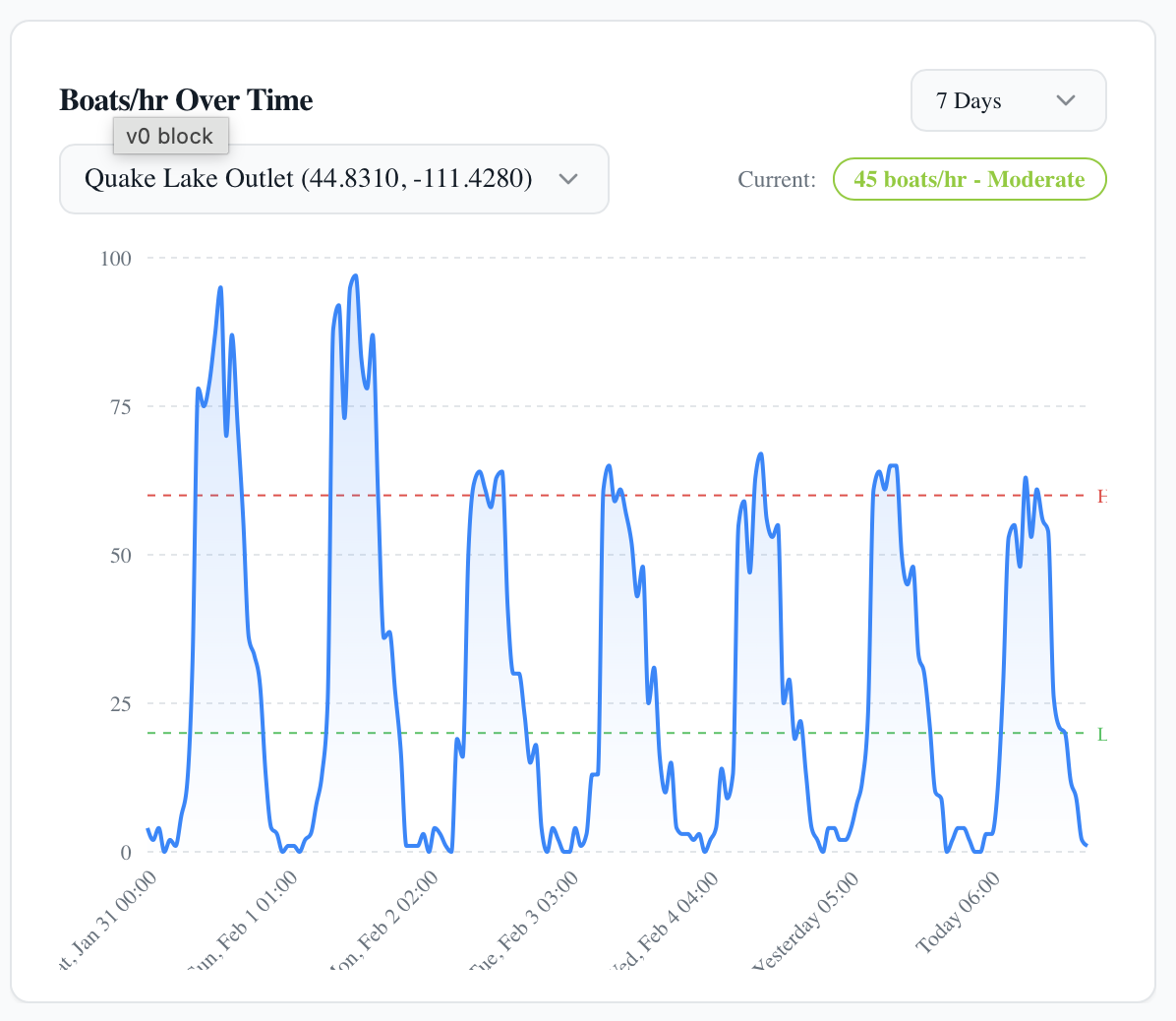
Not weeks later — every 10 minutes
- Identify peak congestion windows
- Respond to events, weather, closures
- Support operations and planning
Zero-infrastructure deployment
No power, no network, no trenching
- Solar + cellular
- Temporary or permanent
- Deploy in hours, not months
Defensible, high-confidence analytics
Image-based counts you can audit
- Fewer false positives than IR
- Explainable anomalies
- Credible to boards and grant reviewers
Overview
Waypoint is building the first AI-powered telemetry infrastructure for outdoor recreation.
Our system combines rugged autonomous field sensors with computer vision models to measure recreational activity on trails, parks, and public lands—delivering real-time, defensible data without permanent infrastructure.
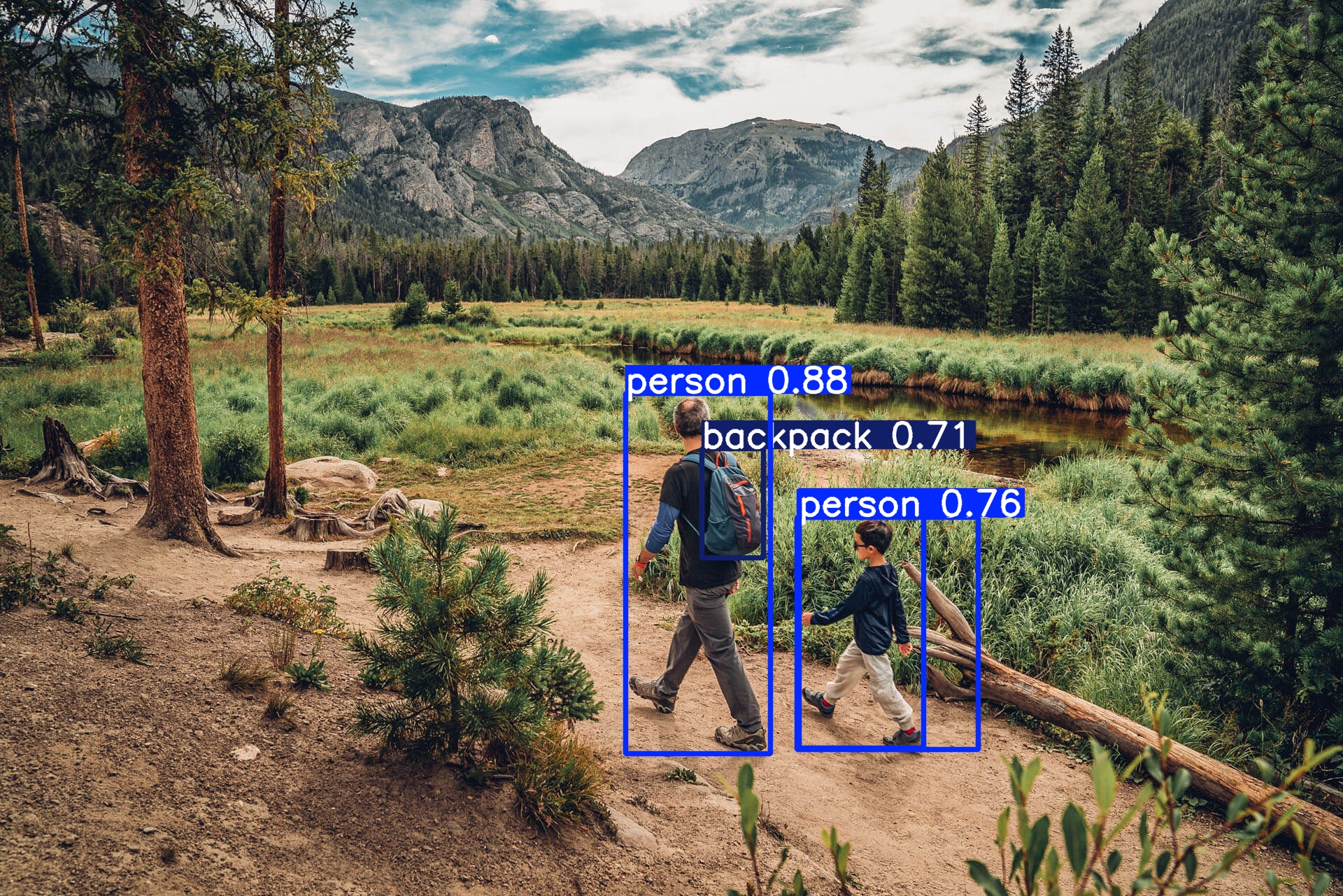
Unlike traditional infrared counters, Waypoint uses AI detection and tracking algorithms to identify individual trail users, classify activity types, and filter noise—producing research-grade datasets for planning and management decisions.
Hardware Collection
Autonomous sensors designed for remote, off-grid deployment
Data Analysis
AI-powered analytics platform for trends and insights
Accuracy Matters
Computer Vision for Recreation Monitoring
Traditional infrared trail counters often struggle with multimodal recreation environments. A single IR sensor cannot distinguish between a cyclist, a group of hikers, or a dog—leading to inflated or unreliable counts.
Waypoint uses computer vision models to identify and track individual trail users, enabling accurate activity classification, duplicate suppression, and directional flow analysis.
IR Counter Challenges
- Groups walking together
- Bicycles and runners
- Dogs triggering counts
- Direction of travel
- Double counting
Waypoint AI Detection
- Activity classification (walk, run, bike)
- Duplicate suppression
- Directional flow analysis
- Group detection
- Noise filtering
Validated through controlled field studies and real park deployments. Our detection and tracking algorithms are continuously refined based on real-world performance data.
Why Waypoint Telemetry Is Different
Technical Infrastructure for Recreation Measurement
Waypoint combines computer vision AI, autonomous field sensors, and real-time telemetry infrastructure to deliver research-grade recreation data—eliminating the limitations of traditional infrared counters.
Computer Vision AI Models
Our proprietary computer vision pipeline detects, tracks, and classifies trail users—automatically processing raw imagery into accurate, research-grade datasets.
Multi-frame tracking algorithms suppress duplicates and filter noise, producing defensible counts for planning and grant reporting.
- Activity classification (walk, run, bike)
- Duplicate suppression & noise filtering
- Directional flow analysis
AI-powered accuracy — not simple beam breaks.
Real-Time Telemetry
Our platform leverages in-field devices equipped with cellular connectivity and a scalable cloud infrastructure to deliver near real-time data and analytics.
As data is captured in the field, it's automatically processed and visualized in our platform — giving you up-to-date insights across all sites.
Perfect for:
- Outdoor recreation monitoring
- Usage analytics
- Planning & resource management
Autonomous Telemetry Infrastructure
Solar-powered field sensors with integrated cellular connectivity eliminate the need for site visits, SD card retrieval, local WiFi, or battery swaps.
Continuous data collection and transmission enable real-time monitoring across distributed recreation sites—without permanent power or network infrastructure.
- Deploy in hours, not months
- Minimal maintenance across seasons
- Dramatically reduced operational costs
Real-time infrastructure without the infrastructure.

Core Capabilities
Real-time visitor counts
Live monitoring of visitor numbers at key access points
Usage patterns over time
Seasonal and long-term trend analysis
Peak period identification
Data-driven insights into high-traffic windows
Location-based telemetry
Geospatial data collection across multiple sites
Remote autonomous operation
Self-sustaining deployments in off-grid locations
Historical datasets
Longitudinal data for research and planning
How It Works
Solar-powered field devices capture activity imagery
Autonomous sensors deployed at trail locations collect visual data continuously
AI detection models identify trail users
Computer vision algorithms detect and classify individual users (hikers, cyclists, runners)
Tracking algorithms filter duplicates and noise
Multi-frame tracking suppresses false positives and eliminates double-counting
Telemetry is transmitted via cellular network
Processed detections and metadata are sent to the cloud platform in real time
Clean datasets power real-time dashboards
Analytics platform produces live metrics, trends, and research-grade exports
Field Deployments
Active Recreation Monitoring Sites
Waypoint systems are currently deployed in active recreation environments, collecting real-time data to validate our detection accuracy and support land management decisions.
Hyland Lake Park Reserve
Multimodal trail monitoring across multiple recreation areas within a regional park system
Bloomington, Minnesota
Lake Girard Trail System
Activity monitoring on popular trail networks and water access points
Montana
Early deployments in progress. These installations are actively collecting data to refine our detection models and validate system performance in real-world conditions.
Hardware Concept
Our field telemetry units are rugged autonomous sensors engineered for remote outdoor deployment—combining integrated solar power systems with cellular connectivity for continuous, maintenance-free operation.
Autonomous Field Sensor
Rugged outdoor sensing units equipped with integrated solar panels for sustained power and cellular modems for real-time data transmission—enabling autonomous deployment in remote locations without manual retrieval or site visits.

Public Information Tag
Every installation includes a weatherproof laminated info sheet mounted near the unit, providing the public with details about the device, its purpose, and how to learn more or report concerns via a simple QR code scan.
Weather resistant
Engineered for year-round outdoor deployment in harsh conditions
Solar powered
Self-sustaining energy system for remote, off-grid locations
Autonomous operation
Minimal maintenance requirements with remote monitoring
Current Status
Pilot Deployments & Research Phase
Waypoint Telemetry is currently in pilot deployments and research phases, working with early partners to evaluate data quality, applications, and long-term potential. This is an early-stage initiative focused on learning and collaboration.
Interested in collaborating?
We welcome conversations with land managers, conservation organizations, government agencies, and research partners interested in exploring pilot programs or learning more about the initiative.